Hwy 10, West of Mandan

Hwy 10, West of Mandan

Monday, December 26, 2016

Wrapping up 2016

Annual cumulative mileage continued its downward trend, this time dropping below 1000 miles for the first time since 2005.  Increased demands at work coupled with continued eldercare responsibilities limited time available to train for and travel to randonneuring events.  I hope to get back on track in 2017 by participating in a complete series of ACP brevets.

The year was not lost to outdoor activities, however.  An ambitious expansion of garden space required considerable attention throughout the summer and resulted in impressive yields of diverse produce, much of which was donated to local food pantries.  My wife and I also hiked over 100 miles of the North Country Trail in North Dakota and Minnesota.  We plan to continue hiking in 2017 while documenting our experiences along the way.


(Allocating more space - and time - for local food)

Thursday, November 17, 2016

Exploring Mandan Villages

The unseasonably warm weather this November has been a boon for cyclists in Bismarck-Mandan as opportunities to ride comfortably this late in the season are rare.  I took advantage of the conditions a couple weekends ago to do a ride focused on visiting archaeological sites along the Missouri River.  This was a ride I planned last winter, guided by my interest in agricultural practices used by native peoples in the region.  The sites I visited were settlements previously occupied by the Mandans, who, along with the Arikaras and Hidatsas, thrived along the Missouri River for hundreds of years following a rich farming culture.

Starting from home I headed south and west to Chief Looking’s Village, located just off Burnt Boat Road in Pioneer Park.  Stopping at the small parking area, I left my bike near the entrance and followed a path west to a plateau overlooking the Missouri River.

(Turning off Burnt Boat Road into Pioneer Park)

(Looking west from the parking lot)

Both rectangular and circular depressions were present at the site, representing previous lodges.  The presence of both types of depressions reflect a transition in lodge design, as early Mandan settlements (1500 AD and earlier) favored rectangular lodges while later settlements favor circular lodges.

(A rectangular depression)

There were numerous educational signs along the path, and I appreciated learning about maternal inheritance within Mandan families, the likely location of previous garden plots, and the story of Chief Looking.

(Home ownership passed from mother to daughter)

(12-20 acres per family!)

(A very nice view of the Missouri River)

The next site I visited was Double Ditch Village, located about nine miles north of Chief Looking’s Village following River Road and Highway 1804.  Despite the narrow shoulder and presence of rumble strips on 1804, I had a smooth commute.  Having biked this section of road numerous times the past 15 years, I know traffic can be difficult and at times dangerous for cyclists.  No worries today, thankfully.

(Take a left at the top of the hill)

(Entrance into Double Ditch Village)

(Park and walk)

Double Ditch Village is impressive in its size (>20 acres), presence of numerous depressions, and two prominent ditches (hence the name).  The ditches were used to protect villagers from surprise attacks from competing tribes.

(One of the major ditches…   …the photo doesn’t do justice to the size)

Excellent signs with up-to-date text and maps were located along the walking path, which followed the periphery of the site.  Walking the entire length of the path took about 20 minutes.  It was a good break from riding!

(Sign describing findings from previous archeological studies)

(Missouri River, looking southwest)

(Massive mounds near the east side of the site are old refuse piles)

From Double Ditch Village, I retraced my route into Bismarck and continued to On-A-Slant Village south of Mandan.  On-A-Slant Village resides within Fort Abraham Lincoln State Park near the mouth of the Heart River.  This commute was the longest of the day, helped in no way by a moderate headwind for most of the southbound route.  No complaints, though.  It was a wonderful day to ride.

(Heading into the park from the north along a nicely paved multi-use trail)

(Confluence of the Missouri and Heart)

(Welcome sign at On-A-Slant Village)

On-A-Slant Village is unique from the other villages in that lodges have been reconstructed at the site, providing visitors with a unique opportunity to experience the interior of structures used for homes and ceremonies by the Mandan people.  Though I previously visited On-A-Slant Village as part of a Girl Scout function with my daughter many years ago, this was my first experience inside a reconstructed lodge.  Though large outside, the confines inside were open but compact, and centered around a fire pit in the middle of the lodge.

(Reconstructed lodges at On-A-Slant Village)

(Fire pit in the ceremony lodge)

(The interior of a smaller lodge, surprisingly well lit by natural sunlight)

(Many depressions are found elsewhere at the site)

As I biked home I couldn’t help but think about the loss of other villages along the Missouri and Heart Rivers, erased from the landscape as Bismarck and Mandan grew from small settlements to established cities.  That said, we are fortunate to have at least a few preserved sites to facilitate a deeper appreciation of local native cultures.

This was an enjoyable ride, with all sites reasonably close to town (total distance travelled was less than 45 miles) with limited climbing.  Altogether, the ride took just under four and half hours, including ample time at each site and one stop in Mandan for food and water.  Best of all, incorporating stops that honored the native history of this wonderful area gave today’s route a special place among my local rides.  I envision building on this theme in 2017 by visiting historic sites near Menoken and Washburn.

Tuesday, October 25, 2016

A Day on Inis Mór

My wife and I are enjoying an extended vacation while visiting our daughter in Galway, Ireland.  I didn’t prepare to bike while visiting, expecting wet conditions from rain typical this time of year.  However, we seemed to have hit the ‘sweet spot’ with the weather, as temperatures have been mild under mostly sunny skies.  In fact, the weather conditions have been nearly identical to those in Bismarck.  I guess this is one instance where bringing North Dakota weather on vacation has been a good thing.

The first of our three tours outside Galway was a visit to Aran islands.  After a short bus transfer from downtown Galway to Rossaveel, we boarded a ferry to Inis Mór, the largest of the three Aran islands.  Exploring Inis Mór can be done by bus tour, horse drawn carriage, bike, or foot beginning from Kilronan.  Recognizing our visit would be brief (about six hours), I opted to rent a bike while my wife and daughter chose the bus.  Before going our different ways, we plotted out a plan to meet atop Dún Aonghasa, a prehistoric stone fort that’s a must-see attraction (and under consideration as a future World Heritage site).

I chose a ‘city bike’ with decent tires, functional brakes, and (mostly) functional derailleurs.  After a slight seat adjustment, I headed out of town on the main road west with the wind to my back.

(The ‘bike hire’ establishment of choice…   …they were closest to the dock)

(Not my Koga-Miyata, but for 10€ I didn’t complain)

(Heading away from the pier…)

(...past the Aran Sweater Market…)


(…and up a gentle hill along roads lined with stone walls)

The scenery was most impressive, with wide expanses pasture land interspersed with small settlements of well-kept houses.  I found the network of stone fences particularly amazing, partitioning out sections of land as far as I could see.  Simply put, the surroundings were nothing like I had encountered in previous travels.

(No easy chore building those fences!)

(A unique ‘Share the Road’ sign)

(Evidence of small-scale agriculture; goats and a garden)

(Friendly mule takes a nibble from my handlebar grip)

The visit to Dún Aonghasa was excellent, despite my aversion to heights.  As planned, I met up with my travel companions at the top of the fort, which made for memorable time together.  We soaked in the surroundings for a half hour before returning to the visitor’s center.

(The bike corral at the visitor’s center)

(The hike up to Dún Aonghasa)

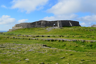
(Dún Aonghasa)

(Inside the fort)

(View of the cliffs east of the fort)

Once at the visitor’s center, the bus schedule provided just enough time to enjoy tea, apple pie, and carrot cake at the best café on the island.  We were fortunate to have a table next to the fireplace.  Lucky!

(The best café on the island has a grass roof)

(Enjoying our time together before venturing back to Kilronan)

From the café, I attempted to ride further west to the Seven Churches.  On the way I encountered two herdsman (one on a bike) and a small group of cattle heading in the same direction.  Not wanting to bother the cattle (or the herdsman), I turned back and retraced my route, stopping once at Dún Eochla, another fort a short distance from the main road.

(Aran Island cattle drive)

(Buildings seemed older on the western half of the island)

(Stone cistern for cattle)

(A steep 500 m climb to Dún Eochla…)

(…but well worth the view)

My return to Kilronan was uneventful, though the weather took a turn with increased winds and light rain.  Though I would have enjoyed exploring the Inis Mór more thoroughly by bike, I was glad to get back.  A nasty head cold was settling in my ears and throat, and I was feeling physically exhausted despite the short distance traveled.  No regrets for not doing more, though.  It was a good day, and I’m glad I had a chance to see much of the island by bike.

(Welcome relief at the end of the ride)

Sunday, September 18, 2016

George S. Mickelson Trail – Part II

My intention was for this to be the last installment reviewing this trail, having ridden the Edgemont to Custer section of the Mickelson Trail in 2014.  My plans were start at Deadwood and ride quickly to Custer along Highway 385, and then return to Deadwood by way of the trail before nightfall.  However, a loose crank bolt in the first six miles of the ride compromised these plans significantly.  Not wanting to push my luck over 112 miles with an uncertain mechanical and few useful tools, I explored my options to salvage the day.

(Starting at the Deadwood Trailhead, 8:00 a.m. sharp!)

(Reviewing my options along Highway 385…   …feeling ‘Closed for the Season’)

Fortunately, the map I brought identified a nearby gravel road with a direct route to the Mickelson Trail.  In fact, the distance from Highway 385 and the Englewood Trailhead was a mere six miles along mostly smooth hardpack.  Even by adopting a slower pace and stopping periodically to tighten the crank bolt, I arrived at the trailhead in less than 25 minutes.

(Smooth riding on this gravel road…)

(…passing directly by a gravel quarry, naturally)

Following a short pit stop at the trailhead, I learned there was a marathon being held from Rochford to Deadwood.  This was another setback, for if I were to head south along the trail I would soon come in contact with heavy traffic.  After a few minutes of mulling this new news, I decided to ride to Rochford anyway.  As a multi-use trail, I certainly wouldn’t be the only cyclist the marathon participants would come in contact with.  Tightening my crack bolt again, I headed south from Englewood along chipped limestone.

(More smooth riding...  ...wide tires at low pressure rolled nicely over this variable surface)

The marathon appeared to be a veteran’s benefit, as there were numerous military personnel participating.  I passed many in full fatigues with standard-issue boots, and even some with what appeared to be full backpacks.  Running/walking 26+ miles in that gear was surely no easy task.  Most impressive!

(Here come the marathoners!)

Riding in the opposite direction of the participants allowed me to find open trail quickly.  As I approached Rochford I soaked up the changing colors of the trees under bright blue skies.  The disappointment of my changed plans dissipated.  It was a turning out to be a good day.

(One of many bridges crossed on the way to Rochford)

(Tunnel shortly before Rochford)

The Rochford Trailhead was a hotbed of activity, with cyclists arriving from Custer as part of the 2016 Mickelson Trail Trek.  The trailhead was also the starting location for what appeared to be a Boy Scout bike ride.  I quickly used the facilities, filled both water bottles, and pointed my bike north.

(Rochford Trailhead)

(A welcome spigot to refill bottles for the ride back to Deadwood)

Not wanting to ride in the same direction as the marathon participants, I opted to take Highway 17 out of Rochford.  My hope was to pass most (if not all) the walkers prior to the Englewood Trailhead and then take the Mickelson Trail the rest of the way into Deadwood.  Despite the absence of a shoulder, the highway was essentially devoid of traffic making for some enjoyable riding.

(Bovine criminals?)

(They appeared peaceful enough from the highway)


My plan to leapfrog the walkers worked mostly.  I passed less than 20 participants in the last 10 miles into Deadwood, making the final descent particularly enjoyable.  Should I have the opportunity to ride the Mickelson Trail in its entire length in the future, I would want to experience this descent again.  Perhaps someday…

(A slight rise to the trail before dropping into Deadwood)